Wilderness Legislation
In October 2017, Rep. Salud Carbajal and Senator Kamala Harris reintroduced legislation to permanently protect nearly 250,000 acres of public land and 158 miles of Wild & Scenic Rivers along California’s Central Coast. Los Padres ForestWatch and our conservation partners — under the umbrella of Central Coast Wild Heritage — have worked for nine years to build widespread support for the legislation among diverse stakeholders throughout the region.
See below for an index map and details about each area addressed by the legislation.
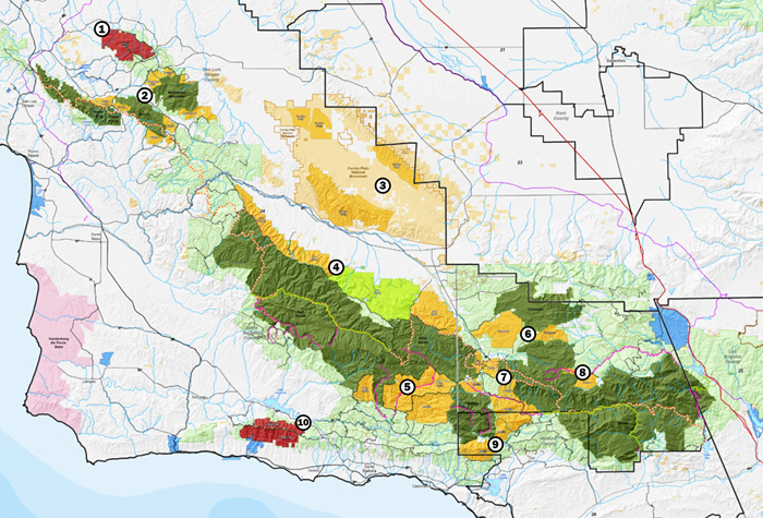
1. Black Mountain Scenic Area
2. San Luis Obispo Wilderness Additions
3. Carrizo Plain National Monument
4. San Rafael Wilderness Additions
5. Dick Smith Wilderness Additions
6. Chumash Wilderness Additions
7. Western Sespe Additions
8. Eastern Sespe Wilderness Additions
9. Matilija Wilderness Additions
10. Condor Ridge
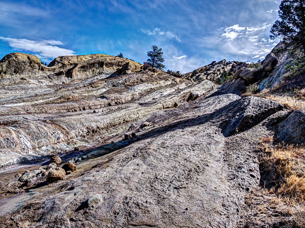
1: Black Mountain Scenic Area
San Luis Obispo County
Located less than an hour’s drive from San Luis Obispo, Black Mountain is one of the few roadless areas in the region that includes oak savannah habitat, a once ubiquitous mixture of grasslands and oaks that is being rapidly destroyed by development throughout the state. Due to its habitat diversity, three sensitive plant species are found here along with a small flowering plant called the Camatta Canyon amole that is found nowhere else in the world. The Scenic Area encompasses the headwaters of the Salinas River which is an extremely important source of water for local communities, agriculture and wildlife. On clear days, visitors are treated to views of the far-off Sierra Nevada and the Carrizo Plain.
The area is threatened by unauthorized livestock grazing and a proliferation of unpermitted roads. Designation of these lands as a Scenic Area would protect the area from development and motorized intrusion while allowing continued mountain bike use in the area.
Black Mountain; image courtesy Jeff Jones, Lumnos Photography
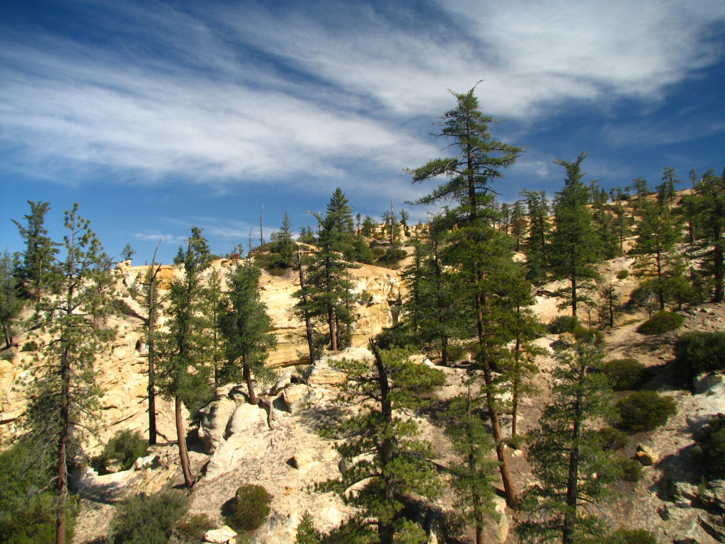
2: San Luis Obispo Wilderness Additions
San Luis Obispo County
These small wilderness additions to the existing Santa Lucia, Garcia, and Machesna Mountain wilderness areas feature pine-crowned peaks, tranquil oak woodlands and grassy meadows interspersed with chaparral covered slopes. The headwaters of the Salinas and Huasna Rivers originate along the flanks of Garcia Mountain, and many seasonal tributaries of the Salinas River have shady streamside groves of hardwoods. California spotted owls have been found in the vicinity and the proposed additions may house the species, along with numerous sensitive plant species. The area already serves as a condor foraging site, and its numerous erosion-caused caves, cavities, and ledges may once again serve as a nesting ground for the majestic bird as it returns to the area. Golden eagles already nest here.
The higher elevations boast views of the snow-capped Sierras and the Carrizo Plain on clear days. Beautiful red rock outcropping and rounded red boulders jut out from the densely vegetated slopes and several seasonal tributaries of the Salinas River have shady streamside woodlands. A historic lookout tower has been converted to a field station and observation deck for endangered California condors that forage the area – this structure and the adjacent campground and road are excluded from the proposed wilderness.
Santa Lucia Wilderness Addition; image courtesy Jeff Jones, Lumnos Photography
3: Carrizo Plain National Monument
San Luis Obispo County
These proposed wilderness areas would be the first ever for the Carrizo Plain National Monument, and include Soda Lake (the largest remaining natural alkali wetland in California), the Temblor Mountains (a diverse mix of native grasses and perennial shrubs known as the Upper Sonoran subshrub community), and the Caliente Mountains, a rugged country with sandstone outcroppings and ancient juniper trees, manzanita, scrub oaks, and home to the highest point in San Luis Obispo County.
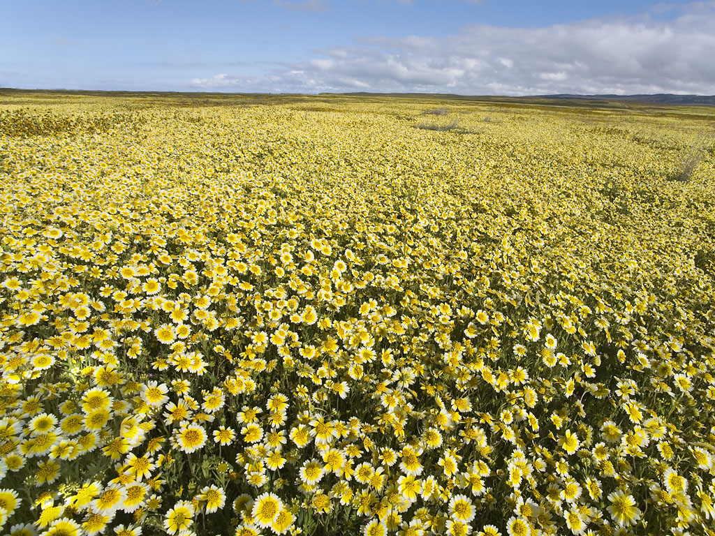
Carrizo Plain Wildflowers; image courtesy Bill Bouton
4: San Rafael Wilderness Additions
Santa Barbara County
Blanketed by chaparral, sage, and pinyon, the San Rafael Wilderness Additions occupy the northern slopes of the Sierra Madre Mountains and drainages leading to the Cuyama River. Notable among these drainages is Lion Canyon, location of one of the first California Condor release sites, and a geologic marvel with massive sandstone outcrops.
There are several spotted owl territories in the area, unique red rock formations, remnants of ancient petrified forests and other paleontological artifacts, and several rare plants and animals. Grassy meadows known as “potreros” characterize the upper elevations, and an abundance of natural springs provide sources of clean water.
Perhaps most significantly, the Fox Mountain unit contains one of the country’s largest assemblages of Native American rock art, including the Eastern Sierra Madre Ridge Archaeological District that is listed in the National Register of Historic Places. The area is threatened by an extensive network of abandoned roads from historic oil drilling activities, and is also vulnerable to future oil development. It is within a High Oil and Gas Potential Area.
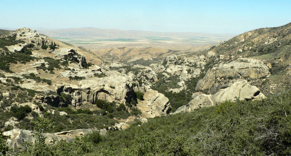
Lion Canyon; image courtesy Craig R. Carey
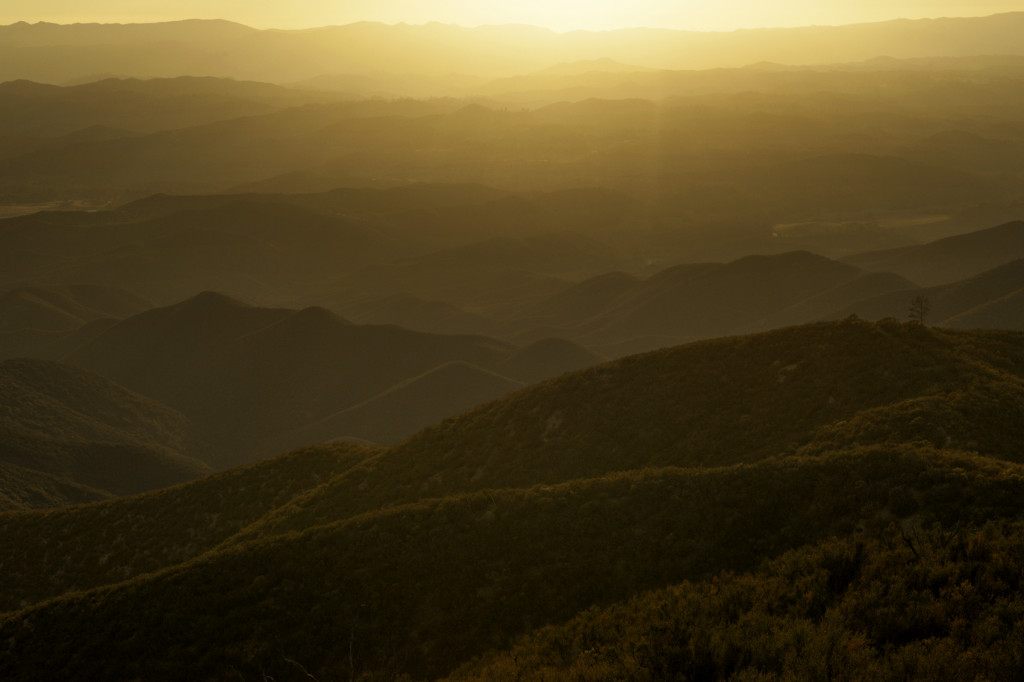
5. Dick Smith Wilderness Additions
Santa Barbara and Ventura County
Chaparral covered slopes, eroded sandstone outcroppings, narrow and deep river and creek gorges, waterfalls, deep pools, and abundant wildlife – these a few of the many fascinating treasures found in the proposed additions surrounding the Dick Smith Wilderness. Here, the coastal climates temper the normally hot and dry inland weather to create a unique and diverse landscape. Wildflower blooms in late February and early March are breathtaking and each year thousands of people make the drive to see these displays. For more adventurous types, many stunning examples of Chumash rock art can be found in caves and rock outcroppings within this area.
The area supports the federally threatened California red-legged frog, federally endangered arroyo toad, the rare Pacific pond turtle, and the two-striped garter snake. The federally endangered least Bell’s vireo and its critical habitat are also found in this unit. Areas within the addition are threatened by oil development, and certain sections are classified as having “high potential” for oil deposits.
Mono and Matilija West; image courtesy Jeff Jones, Lumnos Photography
6. Chumash Wilderness Additions
Ventura County
These proposed additions are dominated by pinyon and Great Basin sagebrush in the lower elevations and conifer stands in the higher elevations, and is a historically significant region in Chumash lore and life.
Dramatic eroded canyons characterize the popular cross-country hiking and skiing area, with soils ranging from deep red to brilliant orange and white – creating a geologically-unique landscape found nowhere else in the Los Padres National Forest. The area likely contains habitat for the federally-threatened Kern primrose sphinx moth, and the federally-endangered Kern mallow. The Upper Cuyama River Area of High Ecological Significance also overlaps with this area.
Rare plant species are found throughout the unit. The area is threatened by illegal off-road vehicle trespass, and is also vulnerable to mining of gypsum, gravel, stone, and minerals, along with a high potential for oil and gas development.
Chumash Badlands; image courtesy Ronald L. Williams and Lighthawk
7. Western Sespe Wilderness Additions
Ventura County
Featuring high-elevation conifer forests and the headwaters of Sespe Creek, this area encompasses the southern flank of Pine Mountain. The area’s sandstone outcrops and unique sandstone geology can be seen from several viewpoints along Scenic Highway 33.
Other areas feature steep narrow canyons with year-around streams with abundant streamside vegetation. Animal species found here include black bear, mule deer, bobcat and mountain lion. As with other potential additions, it provides important habitat for the California Condor.
Sespe Wilderness Expansion Area; image courtesy Eldon M. Walker
8. Eastern Sespe Wilderness Additions
Ventura County
Potential additions to this world famous wilderness include the headwaters of Alamo and Piru Creek. The area of the Fish Bowls features bowl-shaped bedrock pools containing native trout.
There are numerous highly significant archaeological sites, including Chumash rock art sites, across the area. Off-road vehicle trespass is common in the area.
Thorn Meadows/Thorn Point Area
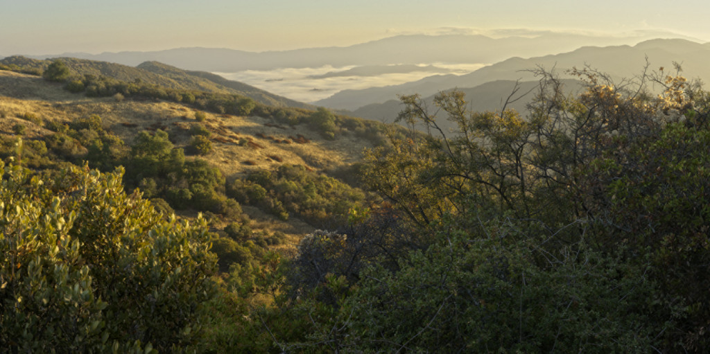
9. Matilija Wilderness Additions
Ventura County
Perennial creeks, such as the North Fork Matilija and Agua Caliente, flow through the area. The North Fork Trail travels along the creek into the very upper portions of the watershed passing incredible waterfalls, beautiful pools teeming with native trout, and rugged canyon walls with sculpted rocky cliffs.
For the native Chumash people, the area has long been a sacred place, evident by the many rock art locations found within this potential wilderness. One key stretch is the Dry Lakes Special Interest Area, which was established for its outstanding botanical values and preserves remnant stands of ponderosa pine along with several relict plant species.
Dry Lakes Ridge; image courtesy Jeff Jones, Lumnos Photography
10. Condor Ridge
Santa Barbara County
With majestic views of the Gaviota Coast, Channel Islands, and Santa Ynez Valley this proposed Scenic Area is vehicle from scenic State Route 154.
An east/west running mountain range where cool northern climates meet with their warm southern counterparts to create an area high in biodiversity and year-round weather that affords plenty of time to take it all in. The area is also home to many endemic species such as the Santa Ynez false-lupine, a Forest Service designated sensitive plant species found nowhere else on earth.
Also located in this area are several headwaters for local coastal drainages that are designated critical habitat for southern steelhead while also providing much needed water resources for local farming and ranching operations.
The Ridge’s special designation would continue to allow mountain biking, vehicle access along West Camino Cielo, and access to and maintenance of the numerous communications towers along its length.
Condor Ridge; image courtesy Bill Dewey