The Bootleg Fire in southern Oregon, the nation’s largest to date, has burned nearly 400,000 acres since starting on July 6 and merging with the smaller Log Fire on July 19. An independent analysis of the landscape that has burned so far has revealed that tens of thousands of acres of recent thinning, fuel breaks, and other forest management failed to stop or slow the fire’s rapid spread.
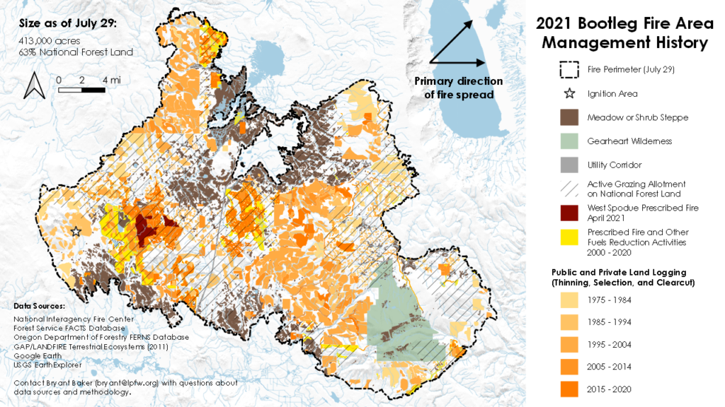
ForestWatch conducted the analysis after meticulously poring over state and federal logging and livestock grazing data as well as historical satellite and aerial images to compile the most extensive forest management history dataset ever released for the area now burning as part of the Bootleg Fire. Key findings of the study (and see explanatory map below) are as follows:
- The fire was driven eastward by wind, and hot, dry conditions across nearly 37 miles of ponderosa and lodgepole pine forests, grassland, and shrub steppe. About 64% of the burned land is managed by the U.S. Forest Service and the rest is private land.
- During the first six days, it burned through nearly 25,000 acres of national forest subject to thinning, prescribed fire, fuel breaks, and other vegetation removal activities promoted as “fuel reduction” as part of the Black Hills and East Hills projects approved in 2012 and 2018, respectively.
- Tens of thousands of additional acres with “thinning” and other forest management from different logging projects also burned during these first several days. During this time, the fire quickly grew to 200,000 acres and officials reported extreme fire weather and fire behavior so intense that firefighters were forced to disengage and retreat.
- Across this same period of significant growth, the Bootleg Fire burned through tens of thousands of acres of intensively managed private forest land to the west and northwest of Gearhart Mountain.
- On average the wildfire moved 3.4 miles per day through public and private forest lands that have been logged over the past two decades compared to an average of 2.1 miles per day through unmanaged Wilderness and Roadless Area to the east according to an analysis of the fire progression data.
- According to Forest Service data, 75% of the national forest land burned in the Bootleg Fire is part of an active grazing allotment administered by the agency. Moreover, nearly 40,000 acres of the burned area is grassland or a mix of grass and shrubs known as shrub steppe, much of which has been grazed as well.
“Contrary to fuel reduction claims or, the Bootleg Fire has raced through much of the landscape that has been logged in one way or another since the 1970s, including over the last few years,” said Bryant Baker, GIS analyst and conservation director of Los Padres ForestWatch.
Several large projects within the Bootleg Fire area are similar to recent logging proposals in the Los Padres National Forest, such as those on Mt. Pinos, on Pine Mountain, on Tecuya Ridge, and in Cuddy Valley.
“Forest fires are driven mainly by weather, climate, and climate change, not by how dense the forest is or how many dead trees there are,” said Dr. Chad Hanson, forest and fire ecologist with the John Muir Project. “Dense forests have a cooler, shadier microclimate, and dead wood soaks up and retains huge amounts of moisture, like big sponges, while thinning and other logging create hotter, drier, and windier conditions that tend to increase fire intensity.”
As climate change continues to worsen, the West will experience increased fire activity across its diverse and unique landscapes. As the Bootleg Fire and other wildfires in recent seasons demonstrate, focusing on the amount of native vegetation as “fuel”—especially far away from human communities—is ineffective and counterproductive. It also increases carbon emissions, exacerbating climate change, as over 200 climate scientists and top ecologists have noted.
Wildfire science continues to show that investments in home hardening, defensible space around structures, better alert and evacuation systems, neighborhood shelters, and other community-focused efforts provide a more efficient way to protect lives and property. These concepts and strategies for their application are detailed in a recently published report, Working from the Home Outward: Lessons from California for Federal Wildfire Policy, prepared by Environment Now and co-authored by forest, shrubland, and fire scientists from multiple states.
As a survivor of the Almeda fire (2020) in southern Oregon, which caused the largest loss of homes in Oregon’s wildfire history, Dr. Dominick A. DellaSala, Chief Scientist, Wild Heritage, called on decision makers to assist fire-displaced families still without homes and to support home hardening of existing homes. DellaSala stated, “Every dollar spent on backcountry logging is a dollar that could have been spent on protecting lives, homes, and assisting in relocation efforts as large portions of the West deal increasingly with massive urban and suburban fires triggered by an overheating planet caused mainly by fossil fuel emissions and widespread logging.”
As part of the reconciliation and infrastructure packages, Congress is currently considering including proposals from some Democrats to dramatically increase taxpayer subsidies for “thinning” and other forest management activities under the rubric of “fuel reduction” and fire management, such as sections 2 and 10 of the 21st Century Conservation Corps Act. In this political context, the largest current fire in the US, the Bootleg fire, is being used by some elected officials and pro-logging interest groups to promote such legislative proposals, but emerging evidence points to a very different conclusion.





Comments are closed.