Click here for an interactive map.
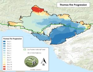
The Thomas Fire’s spread over time. Note: blue areas represent the fire perimeter earlier in its progression and red areas represent the fire perimeter later in its progression. The northernmost area of the fire indicating recent fire activity was mostly due to backburning operations conducted by firefighters. Click on the map for a larger version.
Background
The Thomas Fire actually started in the early evening on December 4 as two separate fires approximately four miles apart: one along Koeningstein Road and one between Thomas Aquinas College (the fire’s namesake) and Steckel Park just north of Santa Paula. As the fires ignited after sunset, an air response with tanker jets was not possible. The two fires eventually combined and grew rapidly between Ojai and Ventura, jumping Highway 150 and burning over 100,000 acres in just two days. The fire burned hundreds of homes in Ventura and Ojai during its first few days. Firefighters were able to save many homes in Ventura and keep the fire from moving into the main residential areas in Ojai. However, the fire jumped Highway 33 and Highway 101 before moving up the coast toward Carpinteria. The Thomas Fire spread into the Los Padres National Forest around Ojai and burned in virtually all directions.
Three weeks later, the Thomas Fire and associated backburning operations had burned over 281,000 acres including more than 152,000 acres of national forest land. The entire Matilija Wilderness and smaller areas within the Sespe Wilderness were burned, though much of this was due to backfiring operations conducted by firefighters. The fire also scorched the Santa Ynez Mountains and parts of the upper Santa Ynez River watershed during its spread west toward Carpinteria, Montecito, and Santa Barbara and after it jumped Highway 150 again. As of December 24th, it was the largest wildfire since record-keeping began in California. The cause remains under investigation.
Effects on the Los Padres National Forest
The Thomas Fire began by burning a massive swath of private lands before moving into the Los Padres. It now stands as the 3rd largest wildfire in terms of acreage burned within the Los Padres National Forest boundary behind the 2007 Zaca Fire and the 1932 Matilija Fire. Unlike the Zaca Fire, the Thomas Fire has affected proportionally less wilderness area despite encompassing the Matilija Wilderness and burning small sections of the Sespe Wilderness. Other Los Padres areas burned by the fire include: Santa Paula Canyon, Sisar Canyon, Nordhoff Ridge, Wheeler Gorge, Dry Lakes Ridge, White Ledge Peak, Divide Peak, Romero Canyon, San Ysidro Canyon, Cold Spring Canyon, and Rose Valley.
Contrary to many reports during the fire, nearly all of the Thomas Fire area in the Los Padres has previously burned over the course of the last century. In fact, approximately 67% of the area burned in the Los Padres by the Thomas Fire has burned at least once (in several areas more than once) since 1985, and over 82% has burned in the last 50 years. Use the interactive map below to explore the areas burned by the Thomas Fire and how they have burned over more than a century.
