|
August 20, 2007
ZACA FIRE UPDATE
Week Ending August 19, 2007
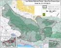
The Zaca
Fire more than doubled in size this week, surpassing the 200,000
acre mark and becoming the third largest wildfire in California
history. Having already consumed 11% of the Los Padres National
Forest, the Zaca Fire will likely become the largest recorded
wildfire in the region, poised to surpass the 220,000-acre
Matilija Fire that burned through Ventura County forest land in
1932.
As the
fire this week marched northeast away from South Coast
communities and towards the Pine Mountain summit on Highway 33,
the Forest Service downgraded some evacuation orders but issued
new warnings in Ventura County. Officials also closed more areas
of forest land in Ventura County. Firefighters constructed dozer
lines inside wilderness areas and began backburn operations
along the Sierra Madre Ridge and Highway 33. By the end of the
weekend, the fire had covered 199,588 acres and was 75%
contained.

At the
beginning of last week, the fire had scorched 94,000 acres and
was only 44% contained. The uncontrolled fire line was burning
in a northeast direction, and had crossed over the Buckhorn
Road, between the San Rafael and Dick Smith wilderness
areas. The Buckhorn is a popular mountain biking route to the
top of Little Pine Mountain. Firefighters had once hoped to
contain the fire on the Buckhorn, but extreme weather conditions
proved to be no match for the fire, which quickly jumped the
lines and became well established in the Indian Creek drainage.
The Zaca
Fire began on July 4, 2007, reportedly ignited by sparks caused
by workers cutting a metal pipe on a ranch in the Santa Ynez
Valley. After being nearly 80% contained on July 26, the fire
jumped containment lines and quickly spread into vegetation that
had not burned in more than a century in the San Rafael
Wilderness Area. Suppression costs to date have exceeded $83.2
million.
FIRE SPREADS NORTHEAST
Earlier in
the week, the fire became well established in Mono Creek, Alamar
Creek, and Agua Caliente in the Upper Santa Ynez River basin. By
the end of the week, the fire had jumped firelines along the
Hildreth Jeepway, pushing nearly ten miles to Monte Arido peak
at the edge of the Matilija Wilderness, where firelines
constructed along Potrero Seco Road stopped any further
progression of the fire in this area.
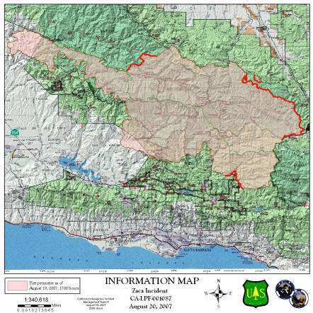
However,
the northeast portion of the fire continued to burn, spreading
into Deal and Rancho Nuevo canyons in the Dick Smith Wilderness
and coming within three miles of Highway 33. Firefighters hope
to contain the fire at the highway, but are constructing
secondary firelines east of the highway on Pine Mountain Summit
in case the fire jumps the highway. Several spot fires have
occurred east of the highway, but so far they have been
extinguished with water and retardant drops.
CONTAINMENT LINES CONSTRUCTED
Firefighters completed bulldozing a containment line this week
along East Camino Cielo and are reinforcing the fuel breaks in
the hills above Montecito and Carpinteria. Dozers also opened up
the old Romero Canyon fire road to access this area.
Contingency lines in the areas of Paradise Road, Camuesa Road,
the Sierra Madre Ridge, Pendola Road, and the Matilija
Wilderness were also completed. A
fireline was established from Potrero Seco Ranch to Hildreth
Jeep trail on the westside of the Matilija Wilderness.
FIRE REGAINS STRENGTH ALONG SISQUOC RIVER
This week,
officials were granted permission to create a dozer line along
2.1 miles of the Sweetwater Trail, which passes through the San
Rafael Wilderness between the Sierra Madre Ridge and the Sisquoc
River. Normally, the Wilderness Act prohibits bulldozers and
other mechanized equipment in wilderness areas, but there is an
exception for fire suppression activities. This exception was
granted by the Regional Forester, the top Forest Service
official in California.
However,
towards the end of the week, the fire became well established in
Sweetwater and Foresters Leap Canyons above Sisquoc Canyon, and
firefighters were pulled off the line because of the extreme
fire danger and concern for firefighters safety. The fire is now
spreading down the Sisquoc River canyon, passing through the
Sisquoc Condor Sanctuary and along the north side of Hurricane
Deck. This coming week, firefighters are planning to conduct
burnout operations at Bates Canyon Road and Sierra Madre Ridge
to stop the downstream progression of the fire.
NEW EVACUATIONS ISSUED
At the beginning of the week, officials downgraded the
Evacuation Order for residents of the Paradise Road community,
Los Prietos Boys Camp, Paradise Store and the Rancho Oso Guest
Ranch. The Lower Santa Ynez River Recreation Area campgrounds,
day use areas and trailheads will remain closed.
At the end of the week, officials issued two new evacuation
notices. On Friday, August 17, an evacuation notice was issued
for East Camino Cielo Road from Gibraltar Road east to the
Ventura County line. And on Saturday, officials ordered a
Precautionary Evacuation for residents
along the
west side of Highway 33 from the Ventura/Santa Barbara County
Line to Pine Mountain Summit.
Also on Friday night, the CHP closed Highway 33 from Wheeler
Gorge to Ventucopa to all traffic except residents, and later
closed the highway to all traffic.
FOREST CLOSURE EXPANDED
On
Tuesday, August 14, the U.S. Forest Service announced that it
was expanding its
public closure order on the Los Padres National Forest. The
closure order now extends from Highway 166 in northern Santa
Barbara County to the Lockwood Valley area east of Highway 33 in
Ventura County, encompassing 888,000 acres, including the entire
San Rafael Wilderness, Matilija Wilderness, Chumash Wilderness,
and a portion of the Sespe Wilderness, and adjacent national
forest lands. The closure prohibits all public entry to national
forest lands, trails, roads, and recreation sites. The Forest
Service imposed the closure because of the difficulty of
evacuating forest visitors from remote areas should the fire
spread.
CHEMICAL RETARDANT DROPS INCREASE
On August
12, officials enlisted a large jet-powered DC-10 tanker to
conduct several retardant drops. The DC-10 carries up to 12,000
gallons of fire retardant – enough to coat eight football
fields.
Stay tuned for next week's
Weekly Update of the Zaca Fire. For information updated daily,
see the Inciweb
website. Due to high traffic, this website often has long delays
or does not work. Ray Ford - who is intimately familiar with the
Santa Barbara backcountry - publishes an informative (and just
about daily) update of the fire's progress on-line in the
Santa Barbara Independent.
|