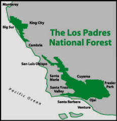
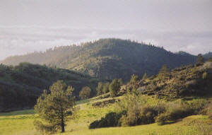
The Los Padres National Forest is California’s second largest
national forest, extending nearly 220 miles across the scenic
Coast and Transverse Ranges. Rising from the Pacific Ocean to
over 8,800 feet in elevation, these wildlands form the backdrop
of many local communities in Santa Barbara, Ventura, San Luis
Obispo, Monterey, and Kern Counties.

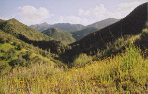
Much
of this land is steep, rugged coastal mountains along the Santa Lucia, La Panza, San Rafael, Santa Ynez, and Sierra Madre ranges. Exciting recreation opportunities abound
here, including hiking,
backpacking, camping, horseback riding, hunting, angling, kayaking, and mountain
biking. These activities boost local economies while attracting
visitors from t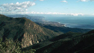 he urban centers of Los Angeles, San Francisco,
and the southern San Joaquin Valley. In fact, the Los
Padres is one of the most heavily-visited national forests in
the nation, with over 1.8 million people exploring this
magnificent area each year. he urban centers of Los Angeles, San Francisco,
and the southern San Joaquin Valley. In fact, the Los
Padres is one of the most heavily-visited national forests in
the nation, with over 1.8 million people exploring this
magnificent area each year.

The
Los Padres is at the center of North America's only
"biodiversity hotspot," one of the Earth's biologically richest
and most endangered ecoregions. The forest forms the hub of a
vast matrix of public lands in central California, including the
Carrizo Plain National Monument, the California Coast
 National
Monument, three national wildlife refuges, a national marine
sanctuary, and other public wildlands. It is here that the
marine coastline meets three other ecological regions to form
one of the richest varieties of ecosystems in the world,
including sea coast and marine
habitats, redwood forest, mixed conifer forest, oak woodland,
grassland, pinon-juniper woodland, riparian, chaparral, coastal
sage scrub, and semi-desert. National
Monument, three national wildlife refuges, a national marine
sanctuary, and other public wildlands. It is here that the
marine coastline meets three other ecological regions to form
one of the richest varieties of ecosystems in the world,
including sea coast and marine
habitats, redwood forest, mixed conifer forest, oak woodland,
grassland, pinon-juniper woodland, riparian, chaparral, coastal
sage scrub, and semi-desert.

The forest provides habitat
for 468 species of wildlife and over 1,200 plant species,
including over 90 species at risk of extinction, more than any
other national forest in the 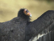 state. These species include the
San Joaquin kit fox, steelhead, Smith’s blue butterfly,
California spotted owl, bald eagle, California red-legged frog,
arroyo toad, and California jewelflower. The forest
is also the focus of efforts to reintroduce the California
condor, one of the world's most endangered species. Click
here to read
more about our
region's unique wildlife. state. These species include the
San Joaquin kit fox, steelhead, Smith’s blue butterfly,
California spotted owl, bald eagle, California red-legged frog,
arroyo toad, and California jewelflower. The forest
is also the focus of efforts to reintroduce the California
condor, one of the world's most endangered species. Click
here to read
more about our
region's unique wildlife.

The Los Padres contains ten
wilderness areas totaling 876,012 acres, nearly half of the
total Los Padres land base. The San Rafael Wilderness contains
the Sisquoc Condor Sanctuary, and was the first-ever primitive
area designated as wilderness. The Ventana Wilderness contains
the southernmost stands of ancient coast redwoods, and is one of
only a few coastal wilderness areas in the nation. The Sespe
Wilderness contains southern California’s last undammed river –
Sespe Creek – as well as the Sespe Condor Sanctuary and the
Piedra Blanca National Recreation Trail.

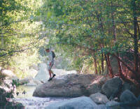 The Los Padres was originally
established to protect the pristine water sources for the
coastal communities surrounding the forest. Today, the Los
Padres encompasses 1,134 miles of rivers and streams, providing
water for urban and agricultural use, habitat for rare and
at-risk species, and exciting recreation opportunities.
Eighty-four miles of Wild & Scenic Rivers – including the Sespe,
Sisquoc, and Big Sur Rivers – flow through its boundaries, and
the Sisquoc River has been called “the most pristine stream in
southern California.” Healthy and freeflowing waterways are a
vital part of this landscape. The Los Padres was originally
established to protect the pristine water sources for the
coastal communities surrounding the forest. Today, the Los
Padres encompasses 1,134 miles of rivers and streams, providing
water for urban and agricultural use, habitat for rare and
at-risk species, and exciting recreation opportunities.
Eighty-four miles of Wild & Scenic Rivers – including the Sespe,
Sisquoc, and Big Sur Rivers – flow through its boundaries, and
the Sisquoc River has been called “the most pristine stream in
southern California.” Healthy and freeflowing waterways are a
vital part of this landscape.

Many areas of the Los Padres
have cultural and spiritual significance to Native peoples. About
one hundred prehistoric rock art sites are
found in the Los Padres. These fragile and unique sites
represent one of the richest records of prehistoric rock art
 in
the world, and are part of an estimated 20,000 cultural sites
in the forest, including the remains of
ancient villages, burial sites, rock shelters, and ceremonial
locations. Certain peaks and other landforms continue to provide
spiritual and cultural value to Native American communities. in
the world, and are part of an estimated 20,000 cultural sites
in the forest, including the remains of
ancient villages, burial sites, rock shelters, and ceremonial
locations. Certain peaks and other landforms continue to provide
spiritual and cultural value to Native American communities.

Today, the forest
is facing more threats than at any other time in history. The
U.S. Forest Service is the agency charged with managing these
public lands, but the agency often approves projects that are
not in the public interest. Oil and gas drilling, livestock
grazing, off-road vehicle abuse, mining, and other extractive
industries are causing significant impacts to wildlife habitat,
wilderness values, clean water, and recreation opportunities.
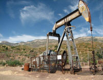 The Los Padres is
the only national forest in California that contains commercial
quantities of oil and gas. Drilling now occurs on 15,000 acres
and near some of the most sensitive areas of the forest - areas
like the Sespe Condor Sanctuary and the Sespe Wilderness. The agency is proposing to
expand drilling into even more areas. The Los Padres is
the only national forest in California that contains commercial
quantities of oil and gas. Drilling now occurs on 15,000 acres
and near some of the most sensitive areas of the forest - areas
like the Sespe Condor Sanctuary and the Sespe Wilderness. The agency is proposing to
expand drilling into even more areas.
Commercial
livestock grazing allotments cover nearly half of the Los
Padres, and a recent study revealed that over three-fourths of
these areas do not comply with the National Environmental Policy
Act. In some areas of the forest, improperly managed livestock
trample fragile streams, pollute waterways, and harm rare
wildlife.
And off-road
vehicles (ORVs) are invading more and more areas of the forest.
There are currently 451 miles of ORV routes and the forest
service is proposing to open up more than 730,000 acres to ORV
access. Despite this widespread access, renegade off-roaders
have blazed hundreds of miles of illegal trails through fragile
areas of the forest. These roads, and the erosion caused by them, are the
leading cause of water pollution in the national forest.

 We are working to
immediately reverse these threats. These are public lands, and
we believe that they should be managed and protected in the
public’s interest. Join us in achieving our vision of healthy
ecosystems, pristine rivers, and wild landscapes along
California’s Central Coast! We are working to
immediately reverse these threats. These are public lands, and
we believe that they should be managed and protected in the
public’s interest. Join us in achieving our vision of healthy
ecosystems, pristine rivers, and wild landscapes along
California’s Central Coast!
|