|
* * UPDATED
* * October 3, 2006
WILDFIRE BURNS ACROSS MORE THAN
160,000 ACRES OF THE SESPE WILDERNESS
Fire Fully
Contained; Public Closure Still In Effect for All Ventura & Kern
County Forestland; Officials Begin to Evaluate Burned Areas
Ventura County,
Calif. - A wildfire that started on Labor Day near Pyramid Lake
is now 100% contained after burning more than 162,700 acres of remote wildlands in
the Los Padres National Forest. It was the fifth largest fire in
state history, several times prompting officials to
issue evacuation notices and close large areas of the forest to
public entry.
The Day Fire
burned for four weeks through 254 square miles of chaparral and
scattered pines in and around the Sespe Wilderness, a
remote area with steep and rugged terrain. Investigators have
determined that the fire is human-caused, and that it resulted
from someone burning a small amount of debris within the Los
Padres National Forest. No arrests have been made. To date,
suppression costs have exceeded $73 million.
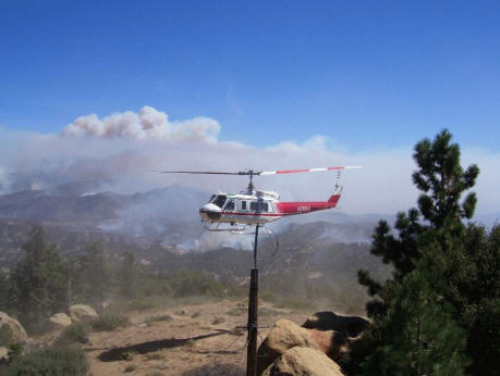
A helicopter at
Mutau Flats on September 20. Smoke
hovers over the Sespe Wilderness in the distance.
Several times last
month, officials issued evacuation notices to communities
threatened by the fire, including Upper Ojai, Fillmore, Rose
Valley, Matilija, Lockwood Valley, Camp Scheideck, Ozena,
Frazier Park, Lake of the Woods, and Pine Mountain Club. The
fire also forced the closure of several roads, including
Interstate 5, Highway 33, and Lockwood Valley Road. The
fire destroyed 11 structures, including two barns, three
trailers, a cabin, and five vehicles. Seven minor injuries were
also reported. ForestWatch thanks the firefighters for their
hard work in protecting all of the communities threatened by the
Day Fire.
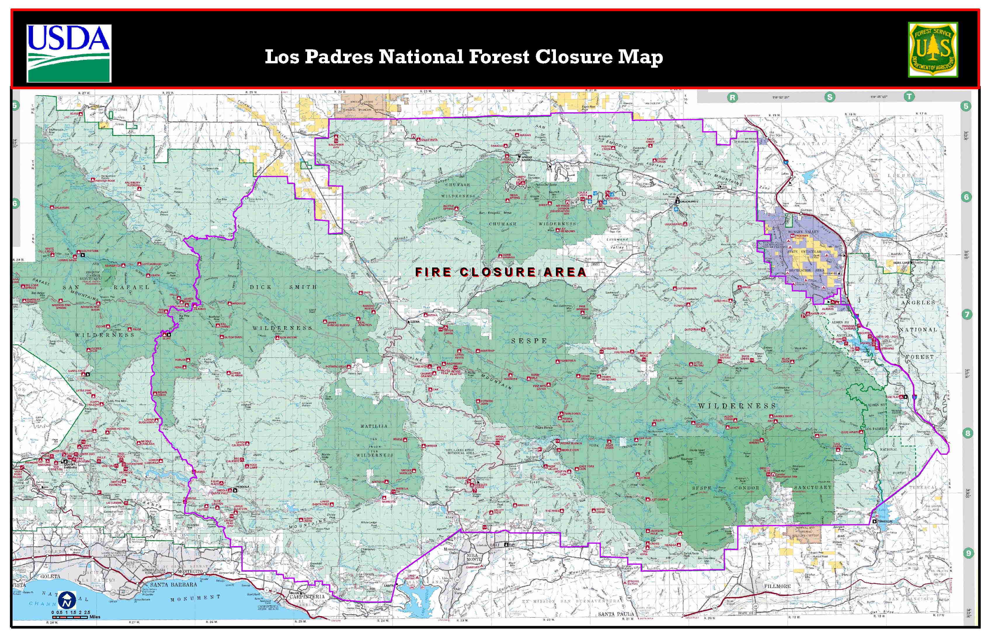
Current Status of Forest & Road Closures
Since September
18, the U.S. Forest Service has barred
public entry into vast portions of the Los Padres because of the
extreme fire danger. This closure will remain in effect until
officials declare that the fire is "controlled," or until all
remaining hot spots that could potentially jump the lines have
been extinguished.
The closure encompasses
all national forest lands within
Ventura County and Kern County. In addition, national forest
lands in southern Santa Barbara County northeast from East
Camino Cielo and Cold Springs Trail are also closed to public
entry. The Forest Service has also prohibited campfires and
charcoal barbecues in all areas of the forest.
These closures and
restrictions will remain in effect until further notice. Click
here for a map
showing the area under closure.
As of today, all
road closures have been lifted. However, several roads in the
national forest remain closed because they are within the
boundary of the closure order.
Sespe
Wilderness, Wild & Scenic River
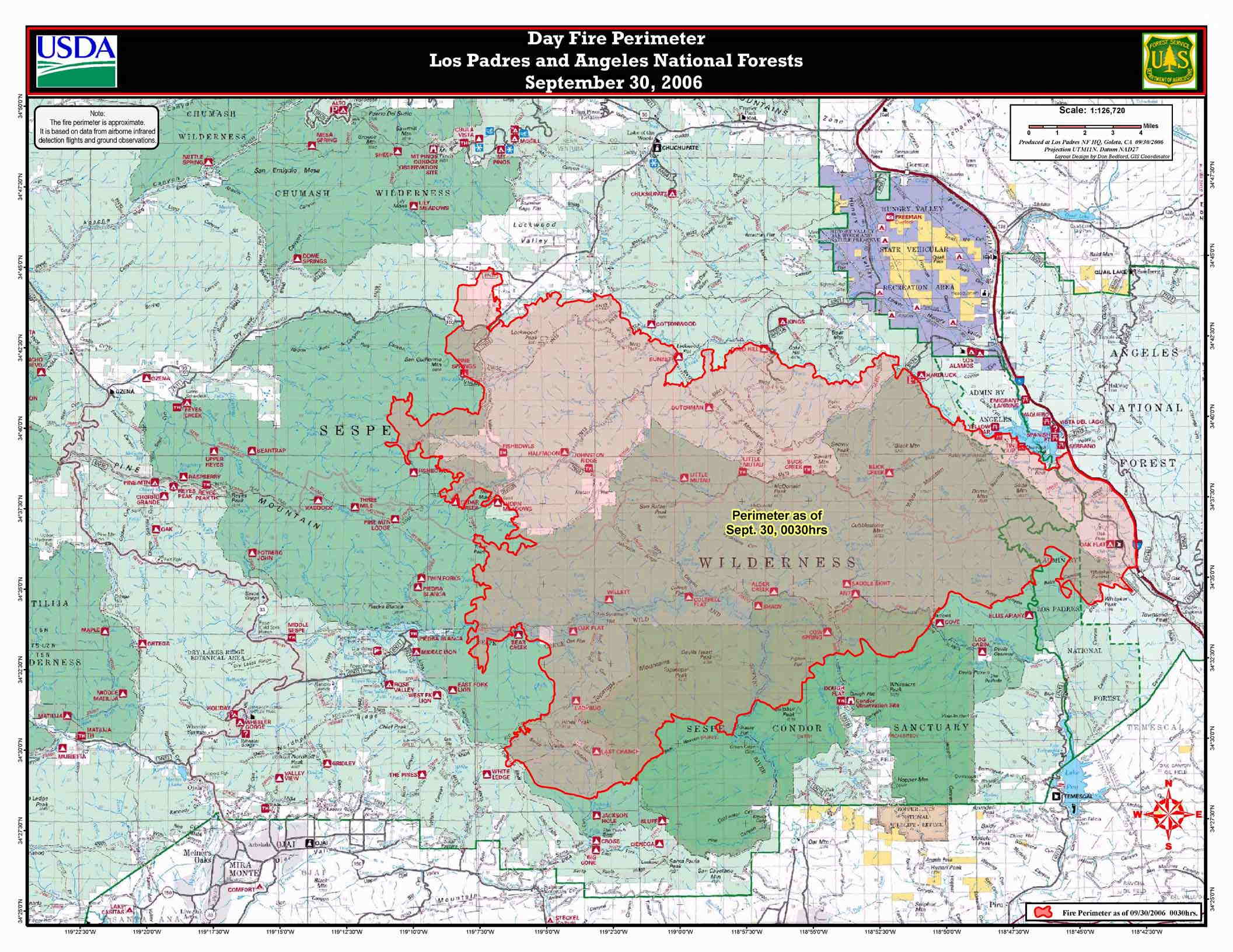
The fire burned
nearly one-half of the 219,700-acre Sespe Wilderness Area, the
second-largest protected area in the Los Padres forest. Several popular backcountry
campsites and trails - including Little Mutau, Buck Creek, the
Johnston Ridge Trail, Thorn Meadows, and Ladybug Camp on the Red
Reef Trail - have been affected.
The fire has also
burned across the upper reaches of the Sespe Wild & Scenic
River, from Bear Camp near Piedra Blanca downstream to the
confluence with Tar Creek.
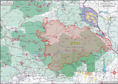
The burn area is
shown in red, as of 9/30/06. Click the map to zoom in.
Impacts to the
Forest
Fires are a
critical component of this chaparral ecosystem, and have
occurred here for thousands of years. While the burn area will
look remarkably different, the vegetation and wildlife will
quickly reestablish across the area. Visitors to this area over
the next few years will be able to witness the vigorous
regeneration of this dynamic ecosystem.
As many as 4,852
firefighters and 41 dozers constructed 163 miles of fire lines
around the fire. Aircraft were also "painting the hills with fire
retardant," according to one official. As of September 18,
aircraft had dropped 500,000 gallons of retardant
on the Day Fire. Current figures are not available, but we
believe that amount has at least doubled to more than one
million gallons. The amount of retardant being dropped is of
concern, since some retardants degrade into toxic compounds that
can kill fish and other aquatic wildlife.
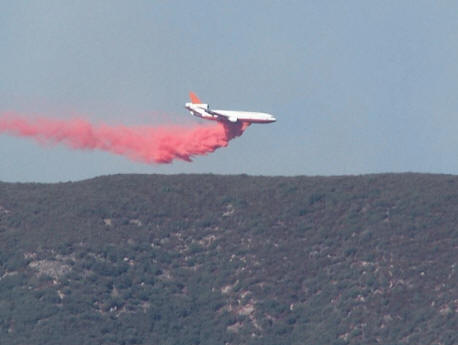
A DC-10 can
drop as much as 12,000 gallons of retardant at a time. More than
500,000 gallons of retardant have been dropped to protect homes
in the
Upper Ojai Valley and other areas of the forest.
Officials are
beginning to assess the effect of the fire on rare wildlife. The
fire burned through habitat for the California condor, arroyo toad, red-legged
frog, and steelhead. The fire has
burned nearly one-half of the Sespe Condor Sanctuary, an area
set aside to protect the critically endangered California
condor.
The fire also
burned through a large portion of the Sespe Creek watershed, leaving hillsides vulnerable
to erosion. This could impact steelhead and arroyo toad
populations that use the creek for habitat. A small herd of
about 30 bighorn sheep also resides in the Sespe Wilderness burn
area.
There have been
some success stories. Firefighters have been able to save some
Native American pictographs and historic mining structures in
the Mutau Flat area, as well as several historic lookout towers.
Several homes in the Mutau Flat area were protected, and dozens of homes were spared recently in the
Lockwood Valley.
What's Next
Work on the Day
Fire continues as crews focus their efforts on "mop up" of
remaining hot spots in the fire interior. In the days ahead,
firefighters will also be rehabilitating constructed fire lines
to help minimize erosion, and collecting and hauling out fire
hose, pumps, portable tanks and other equipment that's no longer
needed.
A Burned Area
Emergency Reponse (BAER) team is conducting an assessment of the
burned area to determine what immediate treatments, if any, are
needed to help stabliize soil; control sediment, debris movement
and water flow; prevent impairment of ecosystems; and mitigate
threats to areas downstream.
The BAER team is
beginning its assessment on the Ojai Ranger District and hopes
to complete it by the end of this week. They will then start the
assessment on the Mt. Pinos Ranger District and hope to have
that assessment completed by mid-October.
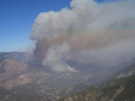
View of the Sespe Wilderness from Thorn Lookout on September 20.
|

