|
July 20, 2006
STATE OF CALIFORNIA ASKS FEDS
TO PROTECT LOS PADRES ROADLESS AREAS
Governor
Files Petition to Protect Over 4.4 Million Acres in California
From Roadbuilding and Development; 636,000 Acres of Los Padres
Roadless Areas at Stake
Sacramento, CA - Today, the
State of California filed a petition with the U.S. Secretary of
Agriculture to permanently protect all Inventoried Roadless
Areas in the state. If approved by the federal government, it
would keep 4.4 million acres - or 21 percent of California's
national forests - off limits to road construction or
development.
Inventoried Roadless Areas
represent the last undeveloped, unprotected areas of national
forest land in the country. These pristine lands have no roads
or development. They provide large blocks of intact habitat for
rare wildlife, clean water supplies for local communities, and
vast wide-open landscapes for hiking, bicycling, and a host of
other recreational pursuits.
The governor's thirteen-page
petition now heads to Washington, DC where it will be reviewed
by an advisory committee. During the 90-day review period, the
committee will provide recommendations to Agriculture Secretary
Mike Johanns. Based on this recommendation, the Secretary will
decide whether to accept the petition, modify it, or deny it. If
the Secretary accepts it, then the federal government will work
with the State to formally adopt regulations protecting these
roadless areas.
In 2005, the federal government
repealed the 2001 Roadless Area Conservation Rule, which
protected all these areas throughout the country. In its place,
the federal government established a new rule under which states
could petition the federal government for state-specific
roadless protections. California now joins Virginia, North
Carolina, South Carolina, and New Mexico. Arizona, Idaho, and
other states are expected to file petitions by the November 13,
2006 deadline. Some states, including Washington, Oregon,
California, and New Mexico, have also filed a lawsuit to restore
the 2001 Roadless Rule that protected all of America's roadless
areas. That lawsuit is currently pending.
The governor's thirteen-page
petition outlines specific policies to keep roadless areas in
their natural state for generations to come. It would prevent
the building of all new roads, except for those needed for
public health or safety purposes such as forest fire prevention.
Exceptions are also made for existing leases or rights, such as
new roads to existing oil leases. Under such situations, the
land would be returned to its natural state after the road is no
longer needed.
On the same day, the California
Resources Agency and the California Department of Forestry and
Fire Protection appealed the four Southern California forest
plans. The new plan for the Los Padres National Forest would
allow road building in 74% of the forest's Inventoried Roadless
Areas. The State of California also accused the Forest Service
of backtracking on its promise to protect these roadless areas.
The appeals ask Forest Service officials to revise the
management plans to better protect roadless areas while the
petition is pending.
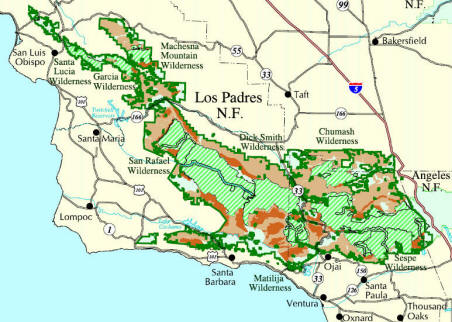
WHAT'S AT STAKE - LOS PADRES
ROADLESS AREAS
The Los Padres contains 51
roadless areas spanning over 630,000 acres in Ventura, Santa
Barbara, San Luis Obispo, Kern, and Monterey counties. These
roadless areas appear in varying shades of brown on the map
below. Permanently protected wilderness areas are shown in light
green.
The roadless
petition would protect all 51 of these roadless areas,
including:
SANTA BARBARA COUNTY
Mono, Diablo,
and Juncal IRAs (Santa Barbara County, 57214 acres) - These
three roadless areas are some of the most wild, unprotected
lands in the Los Padres. Stretching from the Santa Ynez River to
the Dick Smith Wilderness Area, these lands provide popular
hiking, biking, and fishing opportunities, as well as camping at
Caliente. Year-round streams support one of the largest
populations of threatened California red-legged frogs on the
forest.
Fox Mountain
IRA (Santa Barbara County, 52082 acres) - The largest
contiguous roadless area on the Los Padres, Fox Mountain
overlooks the Cuyama Valley and is known for its exposed rock
formations. Lion Canyon was a former release site for endangered
California condors, and this area contains a rich assemblage of
sites important to Native Americans, including the Sierra Madre
Cultural Resource Area.
Horseshoe
Springs & Miranda Pines IRAs (Santa Barbara County, 30333 acres)
- Just twenty miles east of Santa Maria, the Horseshoe Springs
roadless area supports rare animals like the threatened
red-legged frog and the California spotted owl. The Bear Canyon
Trail cuts through this area and is a popular access point for
hikers and mountain bikers.
VENTURA
COUNTY
Sespe-Frazier
IRA (Ventura County, 31270 acres) - The Topa Topa Bluffs
tower above the community of Ojai and serve as a well-known
landmark for this area that stretches from Sespe to Piru creeks.
It includes popular trails like Santa Paula Canyon, Potrero
John, Middle Sespe, Red Reef, and Pothole.
Nordhoff IRA
(Ventura County, 12024 acres) - Spanning the Nordhoff
Ridge, this roadless area provides a source of clean water for
the Ojai Valley. Chief Peak offers a scenic overlook of the
valley and excellent coastal views beyond. This area is popular
with hang gliders, hikers, bicyclists, and horseback riders.
KERN COUNTY
Antimony IRA
(Kern County, 40513 acres) - The Antimony Roadless Area
consists of pinon-juniper woodlands and grasslands in the
northeastern corner of the Los Padres near Frazier Park. San
Emigdio Peak (elev. 7,495') is the dominant landform, and the
area looks out over the San Andreas Fault and the adjacent Wind
Wolves Preserve. The area is within the historic range of the
California condor, Tule elk, and pronghorn, all of which have
been reintroduced nearby. Antimony is popular with hikers and
bicyclists alike.
Sawmill-Badlands IRA (Ventura and Kern counties, 51037 acres)
- These nine parcels border the Chumash Wilderness Area, and
include the Mt. Pinos summit, where visitors can enjoy views
from the Sierras to the Pacific Ocean. This roadless area also
includes the Mt. Pinos Botanical Special Interest Area for
native plant enthusiasts, and habitat for the endangered
California condor.
SAN LUIS
OBISPO COUNTY
Machesna
Mountain IRA (San Luis Obispo County, 12245 acres) - These
four parcels all border the existing Machesna Mountain
Wilderness Area. They're adjacent to a release site for
the endangered California condor, and also contain several
Native American heritage sites.
Big Rocks IRA
(San Luis Obispo County, 11841 acres) - The southernmost
extent of the Santa Lucia Range, east of Arroyo Grande, is
characterized by rolling hills, steep canyons, and large rock
outcrops popular with rock climbers. The area also contains
several Native American heritage sites and habitat for rare
animals like the California red-legged frog and the least Bell's
vireo.
MONTEREY COUNTY
Black Butte IRA (Monterey
County, 2500 acres) - Adjacent to the Ventana Wilderness
Area, the largest wilderness area on the Los Padres, Black Butte
contains mixed evergreen forests. Piney Creek flows through
these parts, providing critical habitat for endangered
steelhead. |