In March, ForestWatch filed a formal objection with top U.S. Forest Service officials, challenging a recent decision by the Los Padres National Forest Supervisor against establishing any new wilderness areas in our local backcountry.
Our objection – joined by seven other conservation organizations – follows on the heels of a draft decision announced earlier this year, specifying the levels of development that will be allowed in sixteen roadless areas spanning 421,000 acres in the Los Padres National Forest in Santa Barbara, Ventura, Kern, and San Luis Obispo counties.
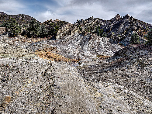
Sespe-Frazier Inventoried Roadless Area; image courtesy Eldon M. Walker
More than 10,000 residents from throughout the Central Coast have demanded that the Forest Service recommend more areas of the Los Padres National Forest for wilderness protection. Such a recommendation would provide immediate, interim protection for some of the last remaining unprotected areas of the forest until Congress acts to permanently protect them under the 1964 Wilderness Act.
Our 16-page objection highlights the fact that in the absence of a Recommended Wilderness designation, these areas remain threatened by oil exploration and drilling, mining, cell towers and other communication facilities, energy development, disposal/sale of public land to private interests, commercial harvesting of wood and other forest products, and replacement of native vegetation with non-native invasive weeds.
Recommending areas for wilderness designation is the first step toward securing permanent protection for these lands under the Wilderness Act of 1964. The Wilderness Act is America’s strongest land conservation tool – wilderness lands are forever protected from development. Camping, hiking, horseback riding, fishing, and hunting are all allowed in wilderness.
Two federal wildlife agencies urged the Forest Service to recommend tens of thousands of acres in the Los Padres National Forest for wilderness protection, and the Forest Service itself even identified wilderness protections as the “environmentally preferred alternative.”
Yet the Forest Service failed to identify even a single acre of the Los Padres National Forest for wilderness protection. Instead, the Forest Service claimed that all 421,000 acres under review were “too close” to existing wilderness areas, and that any new wilderness areas simply aren’t necessary.
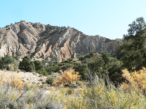
Sawmill-Badlands Inventoried Roadless Area; image courtesy Craig R. Carey
One of the most deserving areas for wilderness recommendation is the Antimony Inventoried Roadless Area, a 40,513-acre expanse of the San Emigdio Mountains near several small mountain communities around Frazier Park in Kern County. Elevations range from 3,250 in the San Joaquin Valley foothills to 7,495 feet atop San Emigdio Peak. Several other peaks – including Brush Mountain, Antimony Peak, Escapula Peak, and Tecuya Mountain – dominate the landscape. San Emigdio Creek bisects the area, and other drainages include Pleito Creek, Santiago Creek, Cloudburst Canyon, Tecuya Creek, Bradley Canyon, and Deadman Canyon. The area borders the Wind Wolves Preserve – the largest privately-owned nature reserve on the West Coast – and is adjacent to the Bitter Creek National Wildlife Refuge, where endangered California condors are reintroduced into the wild. Antimony contains “significant cultural and heritage resources” listed on the National Register of Historic Places, including Native American pictographs and petroglyphs. Two of the nine cultural sites here are “highly significant.”
Part of the San Emigdio Mountains Globally Important Bird Area, the Antimony IRA harbors several bird species of conservation concern. Perhaps most noteworthy among them is the endangered California condor (Gymnogyps californianus), which “uses Antimony extensively for travel and roosting as they soar on uplifted winds along the southern boundary of the San Joaquin Valley.”
Other areas that the Forest Service should have recommended for wilderness protections include the northern slopes of the Sierra Madre Range and portions of the Upper Santa Ynez River basin in Santa Barbara County, and the Cuyama Badlands and the Dry Lakes Ridge area in Ventura County. These areas area all adjacent to existing wilderness areas, and if designated as wilderness, they would provide a more inter-connected network of protected lands throughout our region.
Our objection is the first step in attempting to resolve our concerns with the agency. As part of this formal administrative process, we will meet with forest officials to attempt to negotiate a solution. The Forest Service is required to issue a decision on our objection by this summer.
Read our objection letter here.
More information about what’s at stake can be found here, and supporting documents for the USFS’s Southern California National Forests Land Management Plan are all available on the USFS website; see links below to key documents.
Southern California National Forests Land Management Plan Amendment — Objection Period Letter
Southern California National Forests Land Management Plan Amendment — Los Padres National Forest Draft Record of Decision
Southern California National Forests Land Management Plan Amendment — Final Supplemental Environmental Impact Statement (Final SEIS)
To view the relevant maps and other supporting files, see the full list of Project Documents here.


Comments are closed.